
Agenda
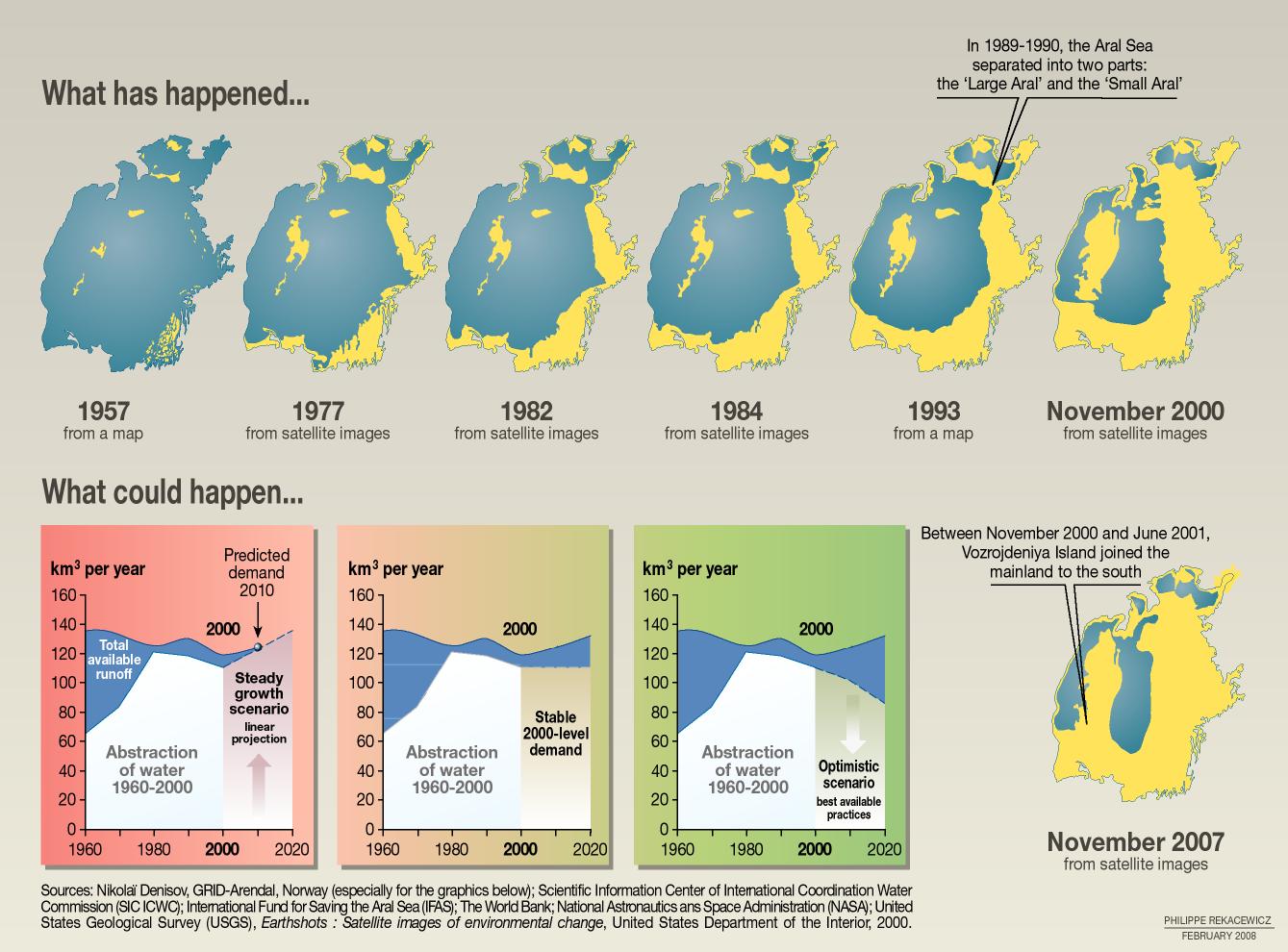
The destruction of the Aral Sea ecosystem has been sudden and severe. Beginning in the 1960s, agricultural demands have deprived this large Central Asian salt lake of enough water to sustain itself, and it has shrunk rapidly. Uzbekistan, Kazakhstan, and other Central Asian states use this water to grow cotton and other export crops, in the face of widespread environmental consequences, including fisheries loss, water and soil contamination, and dangerous levels of polluted airborne sediments.
It is generally agreed that restoring the 1960 sea is not realistic under current water use. The former lake is no longer one body of water: Kazakhstan's Kokaral Dam has brought partial recovery to the North (Small) Aral, while the South (Large) Aral continues to dry.
Humans have made use of the waters of the Aral basin for thousands of years, borrowing from its two major rivers: the Amu Darya, which flows into the Aral Sea from the south; and the Syr Darya, which reaches the sea at its north end. As the twentieth century began, irrigated agriculture in the basin was still being conducted at a sustainable level. After the Russian Empire was replaced by the Soviet Union, this began to change. Traditional agricultural practices were destroyed by collectivization, and Soviet planners sought products that could be exported for hard currency. They placed cotton high on their list, calling it “white gold,” and the Soviet Union became a net exporter of cotton in 1937. Change accelerated in the 1950s, as Central Asian irrigated agriculture was expanded and mechanized. The Kara Kum Canal opened in 1956, diverting large amounts of water from the Amu Darya into the desert of Turkmenistan, and millions of hectares of land came under irrigation after 1960. A crucial juncture had been reached, and after 1960 the level of the Aral Sea began to drop, while diversion of water continued to increase. While the sea had been receiving about fifty cubic kilometers of water per year in 1965, by the early 1980s this had fallen to zero.
As the Aral shrank, its salinity increased, and by 1977 the formerly large fish catch had declined by over seventy-five percent. By the early 1980s, commercially useful fish had been eliminated, shutting down an industry that had employed 60,000. The declining sea level lowered the water table in the region, destroying many oases near its shores.
The devotion to irrigated agriculture had other direct effects as well. Much ecologically sensitive land in the river deltas was converted to cropland, and pesticide use was heavy throughout the Aral basin, resulting in heavy contaminant concentrations in the sea. Overirrigation caused salt buildup in many agricultural areas. By the beginning of the 1990s, the surface area of the Aral had shrunk by nearly half, and the volume was down by seventy-five percent. A host of secondary effects began to appear. Regional climate became more continental, shortening the growing season and causing some farmers to switch from cotton to rice, which demanded even more diverted water. The exposed area of former seabed was now over 28,000 square kilometers, from which winds picked up an estimated 43 million tons of sediments laced with salts and pesticides, with devastating health consequences for surrounding regions. These contaminated Aral dust storms have been reported as far away as the Arctic and Pakistan. Respiratory illnesses were particularly common, and throat cancers burgeoned. Regional vegetation loss may have increased albedo, possibly reducing precipitation.
Full restoration of the 1960 sea is not realistic under current water use. Human and ecological impacts — dust, salinity, health, and livelihoods — persist, especially south of the former shoreline.